


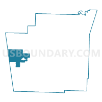
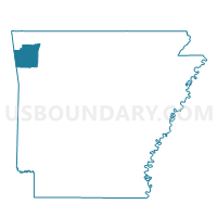
STARR HILL Voting District, Washington County, Arkansas
About
Outline

Summary
| Unique Area Identifier | 528405 |
| Name | STARR HILL Voting District |
| County | Washington County |
| State | Arkansas |
| Area (square miles) | 36.84 |
| Land Area (square miles) | 36.60 |
| Water Area (square miles) | 0.24 |
| % of Land Area | 99.35 |
| % of Water Area | 0.65 |
| Latitude of the Internal Point | 35.96785940 |
| Longtitude of the Internal Point | -94.45824850 |
Maps

Graphs
Select a template below for downloading or customizing gragh for STARR HILL Voting District, Washington County, Arkansas


Neighbors
Neighoring Voting District (by Name) Neighboring Voting District on the Map
- Voting District 18, Adair County, OK
- CANE HILL Voting District, Washington County, AR
- DUTCH MILLS Voting District, Washington County, AR
- ILLINOIS Voting District, Washington County, AR
- LINCOLN CITY Voting District, Washington County, AR
- MORROW Voting District, Washington County, AR
- PRAIRIE GROVE Voting District, Washington County, AR
- RHEAS MILL Voting District, Washington County, AR
Top 10 Neighboring County Subdivision (by Population) Neighboring County Subdivision on the Map
- Prairie Grove township, Washington County, AR (5,904)
- Westville CCD, Adair County, OK (5,354)
- Lincoln township, Washington County, AR (2,249)
- Starr Hill township, Washington County, AR (1,847)
- Cane Hill township, Washington County, AR (1,530)
- Illinois township, Washington County, AR (853)
- Rheas Mill township, Washington County, AR (569)
- Morrow township, Washington County, AR (466)
- Dutch Mills township, Washington County, AR (390)
Top 10 Neighboring Place (by Population) Neighboring Place on the Map
Top 10 Neighboring Unified School District (by Population) Neighboring Unified School District on the Map
- Siloam Springs Schools, AR (21,753)
- Prairie Grove School District, AR (9,100)
- Lincoln School District, AR (7,060)
- Westville Public Schools, OK (5,279)
Top 10 Neighboring State Legislative District Lower Chamber (by Population) Neighboring State Legislative District Lower Chamber on the Map
- State House District 86, OK (36,615)
- State House District 97, AR (34,766)
- State House District 87, AR (30,579)
Top 10 Neighboring State Legislative District Upper Chamber (by Population) Neighboring State Legislative District Upper Chamber on the Map
- State Senate District 35, AR (102,238)
- State Senate District 3, AR (87,143)
- State Senate District 3, OK (80,333)
Top 10 Neighboring 111th Congressional District (by Population) Neighboring 111th Congressional District on the Map
Top 10 Neighboring Census Tract (by Population) Neighboring Census Tract on the Map
- Census Tract 105.04, Washington County, AR (7,102)
- Census Tract 3767, Adair County, OK (5,354)
- Census Tract 110.02, Washington County, AR (4,666)